The road from Muktinath to Jomsom tour covers roughly 20 kilometres through the upper Mustang rain shadow, a landscape that sits geologically and climatically apart from everything south of the Annapurna and Dhaulagiri massifs.
The terrain is arid, the light is flat and intense, the wind picks up reliably by mid-morning, and the cultural fabric along the route is Tibetan in character rather than the Hinduism and Buddhism blend that marks the lower Kali Gandaki valley.
For travellers who have made the effort to reach this altitude, the journey between these two points is not a transfer. It is a continuation of the experience that brought them here.
Muktinath sits at 3,710 metres. Jomsom sits at 2,720 metres. The route descends through one of the deepest river gorges on earth, carved by the Kali Gandaki between Annapurna and Dhaulagiri, two of the world’s highest peaks.
The combination of religious significance, geological drama, and the particular quality of the high-altitude Mustang landscape makes this stretch one of the more memorable single-day journeys available in the Himalayas.
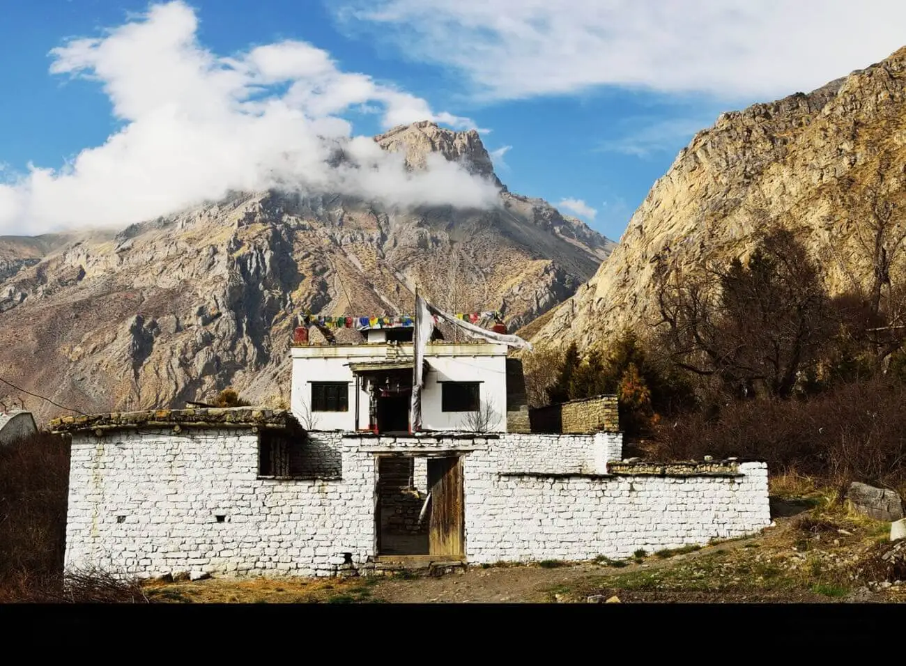
Muktinath Temple
Muktinath Temple sits at 3,710 metres on the slopes of the Thorong La massif and functions as one of the most significant pilgrimage destinations in both Hindu and Buddhist traditions. For Hindus, it is one of the 108 Divya Desams, sacred Vishnu temples, and one of the most remote. For Buddhists, it is Chumig Gyatsa, a place of liberation associated with Guru Rinpoche. The convergence of these two traditions at a single site is unusual and reflects the syncretic religious culture of the Mustang region.
The temple complex includes the main Vishnu shrine, 108 water spouts arranged in a semicircle through which pilgrims pass in sequence, two small Buddhist temples, and an eternal flame fed by natural gas seeping through the ground. The flame burns inside a small temple at the edge of the complex and has been burning continuously for centuries.
Pilgrims travel from across Nepal, India, and the broader Himalayan Buddhist world to reach this site, and the presence of devotees moving through the ritual circuit gives the complex a living quality distinct from heritage sites visited primarily by tourists.
The approach to Muktinath from Ranipauwa, the nearest settlement with accommodation, takes 20 to 30 minutes on foot up a steady incline. Ponies and jeeps are available for those who need them. Arriving early in the morning, before the jeep traffic from Jomsom increases and before the wind builds, gives the site a quieter character and clearer light.
Muktinath to Jomsom Distance: What to Expect on the Road Down
The road distance from Muktinath to Jomsom is approximately 21 to 23 kilometres (13 to 14 miles), passing through Kagbeni along the way. The route descends from Muktinath at 3,760m down to Jomsom at 2,720m, dropping roughly 1,000 metres in altitude over two distinct road segments, Muktinath to Kagbeni (~12 km, steep and mostly paved) and Kagbeni to Jomsom (~11 km, flat, unpaved, and windy along the Kali Gandaki riverbed).
How Long Does the Journey Take?
- By jeep or 4WD: Around 1 to 1.5 hours, the descent is noticeably faster than the climb up
- By local bus: Roughly 2 hours, with stops along the way
- On foot: Most trekkers split this into one full day (5 to 6 hours walking via Kagbeni) or a leisurely two days
One key tip: leave Muktinath before midday. Afternoon winds in the Kali Gandaki valley are strong enough to make the Kagbeni–Jomsom stretch genuinely unpleasant on foot or by motorbike.
The Road Down: Muktinath to Kagbeni
The descent from Muktinath toward Jomsom initially passes through Ranipauwa and drops through open, scrubby terrain toward the Kali Gandaki valley floor. The landscape at this altitude is high-desert in character. Erosion has carved the hillsides into formations that look more like the American southwest than the Himalayan foothills further south. The colours run through ochre, rust, and pale grey. Vegetation is sparse and low.
Kagbeni sits at the confluence of the Kali Gandaki and the Jhong Khola rivers at 2,810 metres and marks the boundary of the Upper Mustang restricted area. The village is one of the most intact medieval settlements in Nepal, with mud-brick buildings stacked against each other, narrow lanes connecting interconnected courtyards, and a red-walled gompa visible from the approach. The Kag Chode Thupten Samphel Ling Monastery dates to the 15th century and is still an active religious institution with resident monks.
The Kali Gandaki at Kagbeni carries the Shaligram stones, black ammonite fossils that wash from the riverbed and are considered sacred manifestations of Vishnu. Pilgrims and traders have been collecting them from this riverbed for centuries. The stones are found nowhere else in the Himalayan region in the concentration and form they appear here, a geological anomaly that contributed to the river’s religious significance long before modern palaeontology explained what the fossils actually are.
Kagbeni to Jomsom
The stretch from Kagbeni to Jomsom follows the Kali Gandaki valley floor for roughly 11 kilometres. This section of the valley is one of the windiest corridors in the Himalaya. By mid-morning, the thermal differential between the Tibetan plateau and the lowlands draws air through the valley at speeds that make forward progress on foot a genuine physical effort.
Trekkers who walked this route before jeep roads were constructed describe it as one of the most demanding sections of the Annapurna Circuit despite its low gradient, purely because of sustained headwind.
The geological context of this section is extraordinary. The Kali Gandaki gorge between Annapurna I at 8,091 metres to the east and Dhaulagiri I at 8,167 metres to the west is the deepest river gorge on earth by the metric of relief between river level and adjacent peaks. From the valley floor at approximately 2,500 metres, both summits rise more than 5,500 metres above. On clear days, the upper flanks and ridges of both mountains are visible from the valley floor, framing the corridor in a scale that is difficult to process from ground level.
Jomsom itself is a functional town rather than a scenic destination. It serves as the administrative centre of Mustang district, has an airport with scheduled flights to Pokhara, hosts a concentration of lodges and restaurants that serve Annapurna Circuit trekkers, and operates as the logistics hub for the upper Mustang region. The old town of Jomsom, on the west bank of the river, has more character than the newer tourist infrastructure on the east bank and is worth exploring before or after flights.
The Spiritual Dimension of the Route
The Muktinath to Jomsom corridor has been a pilgrimage and trade route for longer than recorded history. Salt from the Tibetan plateau moved south through this valley. Grain from the lowlands moved north. The settlements along the route, Muktinath, Ranipauwa, Kagbeni, Khinga, Jomsom, developed as waypoints on this exchange and carry the accumulated cultural and religious deposits of centuries of movement.
Walking the route, or even travelling it by jeep with stops at significant points, connects the traveller to a geography that has held meaning for multiple cultures across a very long time. The Buddhist monasteries along the valley are not museum pieces. They are active institutions. The pilgrims at Muktinath are not re-enacting a tradition. They are continuing one. The Shaligram stones in the Kali Gandaki are collected today as they were a thousand years ago.
This continuity gives the route a quality that purely scenic journeys do not have. The landscape is visually exceptional, but the layers of human meaning accumulated in it over centuries add a dimension that landscapes without that history lack.
Practical Considerations for Muktinath to Jomsom Tour
The route from Muktinath to Jomsom is accessible by jeep on a road that was completed in stages over the last two decades. The jeep journey takes approximately one to two hours depending on road conditions and stops. Shared jeeps depart Ranipauwa for Jomsom in the morning. Private jeep hire allows flexibility over departure time and stops at Kagbeni and other points of interest along the route.
Trekking the full route takes five to seven hours at a comfortable pace with time at Kagbeni. The wind makes the afternoon section to Jomsom uncomfortable and significantly slower than the morning equivalent. Departing Muktinath by 6:30 to 7:00 am gives trekkers the best of the morning light and allows arrival in Jomsom before the wind peaks.
The Mustang restricted area permit is required for travel north of Kagbeni into Upper Mustang. The Muktinath to Jomsom route itself does not require the restricted area permit, as Muktinath falls within the Annapurna Conservation Area rather than the restricted zone. Standard Annapurna Conservation Area permits and TIMS cards are sufficient for this corridor.
Flights from Jomsom to Pokhara operate in the morning only. The same thermal wind that dominates the valley by mid-morning makes afternoon flying operationally unsafe, and Tara Air and other operators on the route do not schedule afternoon departures. Travellers planning to fly out of Jomsom need to be in town the evening before their flight. Flights are frequently cancelled due to visibility and wind conditions, and travellers on tight schedules need to build buffer days or have an overland alternative arranged.
Adventure World Travel arranges customised itineraries through the Muktinath to Jomsom corridor and the broader Mustang region, including restricted area permit handling, accommodation, and guide services. Contact the team to plan your route.
FAQs Over Muktinath to Jomsom Tour in Nepal
1. How long does it take to travel from Muktinath to Jomsom?
By jeep with a stop at Kagbeni, the journey takes two to three hours. Trekking the full route takes five to seven hours at a comfortable pace. Departure by 7:00 am is recommended regardless of mode of travel, as the valley wind builds significantly by mid-morning and makes the afternoon section to Jomsom uncomfortable for trekkers and occasionally difficult for jeep travel on the exposed sections of road.
2. What is the significance of Muktinath Temple?
Muktinath is one of the most significant pilgrimage sites in both Hindu and Buddhist traditions. For Hindus, it is one of the 108 Divya Desams sacred to Vishnu. For Buddhists, it is Chumig Gyatsa, associated with Guru Rinpoche and the attainment of liberation. The site includes a Vishnu shrine, 108 ritual water spouts, two Buddhist temples, and an eternal flame fed by natural gas. Active pilgrimage from Nepal, India, and the broader Himalayan Buddhist world gives the site a living religious character.
3. Do I need a special permit to travel from Muktinath to Jomsom?
The Muktinath to Jomsom corridor falls within the Annapurna Conservation Area and does not require the Upper Mustang restricted area permit. Standard Annapurna Conservation Area entry permits and a TIMS card are sufficient. The restricted area permit is required for travel north of Kagbeni into Upper Mustang proper, which includes Lo Manthang and the villages of the restricted zone.
4. Is Kagbeni worth stopping at between Muktinath and Jomsom?
Kagbeni warrants a stop of one to two hours at minimum. The medieval village architecture, the active 15th-century monastery, the confluence of two rivers, and the Shaligram stone beds of the Kali Gandaki all reward time on the ground. Travelers with flexibility sometimes spend a night in Kagbeni, which gives access to the village in the quieter morning and evening hours when jeep traffic from Jomsom is minimal.
5. Can I fly from Jomsom after completing the Muktinath to Jomsom journey?
Flights operate between Jomsom and Pokhara on a morning-only schedule due to the valley wind conditions that make afternoon flying unsafe. Tara Air operates the route on small twin-otter aircraft. Flights are subject to cancellation based on visibility and wind, and travellers should build a buffer of one to two days into their schedule rather than booking onward travel from Pokhara on the same day as a planned Jomsom departure. Adventure World Travel can assist with flight bookings and contingency planning for the route.